In the fast-paced urban life, planning a perfect city walk is often time-consuming and laborious. You need to gather information, choose attractions, plan a route, and consider personal preferences. However, researchers from the University of Hong Kong, Shanghai Jiao Tong University, MIT, and the Hong Kong Polytechnic University have collaborated to develop a system called ItiNera that simplifies this process and makes your city exploration trip easier and more convenient. ItiNera is an open-domain city itinerary planning system that can generate personalized itineraries based on user requests in natural language.
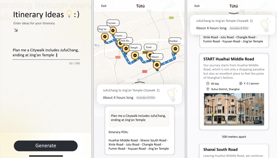
ItiNera is an Open Domain Urban Itinerary Planning (OUIP) system that can generate personalized itineraries directly based on user requests described in natural language. Compared with traditional itinerary planning, ItiNera is not restricted by specific fields and can meet users' personalized needs in more detail.
The core of the ItiNera system is that it combines spatial optimization with large language models (LLMs) to provide customized services. The system extracts and updates POI features through an LLM-based pipeline to create a user-owned personalized POI database. For each user request, ItiNera uses LLM to cooperate with the embedding-based module to retrieve candidate POIs from the user's POI database, then uses the spatial optimization module to sort these POIs, and finally LLM carefully creates a personalized, spatially coherent itinerary. .
The researchers conducted extensive experiments on ItiNera on multiple datasets and conducted online subjective evaluations. The results show that ItiNera is able to provide a more responsive and spatially coherent itinerary compared to existing LLM-based solutions. In addition, ItiNera has attracted thousands of users to use its city trip planning service after being deployed on the TuTu online travel service.
ItiNera's app not only provides an efficient planning tool for city walks, but also provides travelers with a new way to explore the city. It can generate personalized and detailed travel experiences based on users' specific needs and lifestyles, greatly enriching travelers' urban exploration experience.
The research results of the ItiNera system have been made public, and the research team hopes that this system can inspire more research on using LLMs to solve complex urban problems. Through open source, more researchers and developers can participate in the optimization and innovation of this technology.
Paper address: https://arxiv.org/pdf/2402.07204
By combining large-scale language models with spatial optimization technology, ItiNera provides users with personalized and efficient urban walking planning services, improving the travel experience and providing new directions for future urban planning research. Its open source nature also encourages more researchers to participate and jointly promote the progress and development of this technology.